The Fujiwhara Effect is being predicted due to Dual Cyclone Formation in the Bay of Bengal. Read here to learn more about the Fujiwhara effect.
The Bay of Bengal, one of the world’s most active basins for tropical cyclogenesis, is currently witnessing the development of two potential cyclonic systems, with global forecast models indicating a possible Fujiwhara interaction between them.
This raises significant scientific interest and operational concerns, as dual-cyclone interactions are rare and can drastically alter storm tracks, intensity, and rainfall patterns across India and neighbouring countries.
What is the Fujiwhara Effect?
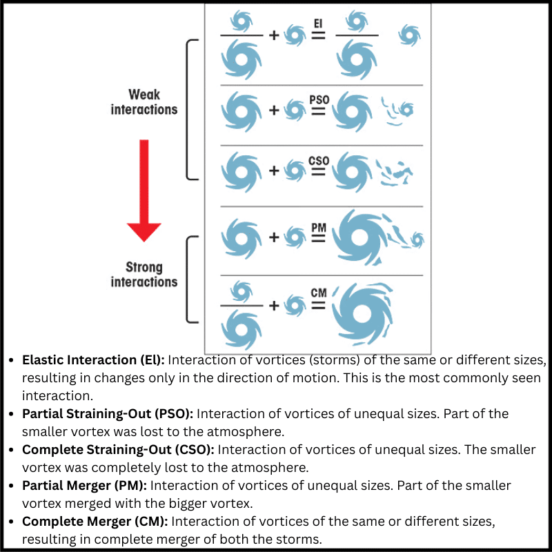
The Fujiwhara Effect is a rare meteorological phenomenon in which two nearby cyclonic vortices begin rotating around a common centre due to the interaction of their wind circulations.
First identified by Japanese meteorologist Sakuhei Fujiwhara in 1921, this interaction typically occurs in the tropical cyclone belt when the two storms approach each other within a critical distance of approximately 1,400 km.
In the Northern Hemisphere, where circulation is counter-clockwise, the interaction can cause both cyclones to rotate around each other, merge, or deflect along entirely new paths.
Conditions Favouring Fujiwhara Interaction
Several atmospheric and oceanic factors must align for the Fujiwhara Effect to manifest:
- Proximity of Cyclones: Cyclones must lie within ~1,400 km of each other. Beyond this range, their wind fields remain too far apart to influence one another.
- Same Rotational Direction: In the Northern Indian Ocean, tropical cyclones rotate counterclockwise, making mutual interaction physically possible.
- Warm Sea Surface Temperatures: SSTs above 26°C are necessary to sustain strong convection, allowing both cyclones to maintain structural strength during interaction.
- Low Vertical Wind Shear: High wind shear can disrupt cyclone symmetry. The Fujiwhara effect requires relatively stable, vertically aligned systems.
How the Fujiwhara Effect Develops

The interaction evolves through distinct stages:
- Close Formation: Two cyclones forming or entering the same region within ~1400 km start influencing each other’s outer wind fields.
- Wind Field Overlap: Their outer rainbands and upper-level winds create deformation zones, gradually pulling the systems closer.
- Coupled Circulation: A shared pivot point is established. Both cyclones begin drifting along curved, interconnected paths rather than their original trajectories.
- Orbiting Motion: The weaker cyclone often rotates around the stronger one. If the energy difference is large, the weaker vortex may lose structural integrity.
- Possible Merger: If the distance between centres shrinks further, the vortices may fuse into a single, larger cyclone with intensified convection.
- Weakening and Collapse: The weaker system may be deprived of essential moisture and heat inflow, leading to rapid weakening.
- Deflection or Separation: If interaction remains moderate, the cyclones may push each other onto diverging tracks, making forecast outcomes highly uncertain.
Key Characteristics of the Fujiwhara Effect
- Mutual Rotation: Both systems orbit anticlockwise around a shared centre, often causing deviations of several hundred kilometres from their projected paths.
- Energy Redistribution: The stronger cyclone may extract momentum, moisture, and vorticity from the weaker system, altering their intensities.
- High Track Uncertainty: The interaction disrupts the steering winds, complicating landfall predictions and intensity forecasts for meteorological agencies.
- Potential Fusion: When vortices get too close, they may merge into a more powerful cyclone, raising disaster risks.
- Stalling Behaviour: The interacting pair often slows down, leading to prolonged rainfall episodes.
Implications for the Bay of Bengal Region
The possible Fujiwhara interaction between the two developing cyclonic systems can have far-reaching consequences:
Forecasting Challenges
Meteorological models struggle to predict:
- landfall location
- timing
- intensity changes
- rainfall distribution
This can delay accurate warning dissemination, affecting evacuation and disaster readiness.
Heavy Rainfall and Flooding
As dual systems interact, their slow movement and enhanced moisture convergence could trigger extreme, prolonged rainfall over:
- Tamil Nadu
- Andhra Pradesh
- Odisha
- West Bengal
- Sri Lanka
- Myanmar
This heightens the risk of urban flooding, riverine floods, landslides, and crop damage.
Intensification of One Storm
Energy transfer or vortex merger may cause one cyclone to undergo rapid intensification, producing:
- powerful winds
- high storm surges
- severe coastal destruction
This is particularly dangerous for densely populated delta regions.
Conclusion
The development of two cyclonic systems in the Bay of Bengal and the possibility of a Fujiwhara interaction underscore the complex dynamics of tropical meteorology.
While the phenomenon is rare, its impact can be profound, altering cyclone tracks, intensifying storms, and complicating disaster preparation.
As climate change warms the oceans and increases cyclone variability, understanding such interactions becomes critical for India’s coastal resilience and early-warning systems.
Frequently Asked Questions (FAQs)
- What is the Fujiwhara Effect?
It is a rare weather phenomenon where two nearby cyclones begin to rotate around a common centre, influencing each other’s track, speed, and intensity.
- Who discovered the Fujiwhara Effect?
The effect was identified in 1921 by Japanese meteorologist Sakuhei Fujiwhara.
- When does the Fujiwhara Effect occur?
It occurs when two cyclonic systems come within ~1,400 km of each other and have similar rotational direction (counter-clockwise in the Northern Hemisphere).
- Why is the Fujiwhara Effect significant for India?
Because the Bay of Bengal frequently produces multiple cyclonic disturbances, making interaction possible. Such interactions complicate forecasts and can intensify storms affecting India’s east coast.
- What are the conditions required for the Fujiwhara Effect?
- Proximity (<1400 km)
- Warm sea surface temperatures (>26°C)
- Low wind shear
- Stable cyclone structure
- Similar rotational direction
Related articles:


Leave a Reply