Earthquakes are a natural phenomenon that occurs when there is a sudden release of energy in the Earth’s crust, resulting in the shaking or trembling of the ground. These events are caused by the movement of the Earth’s tectonic plates and are a common geological occurrence. Read here to learn more.
Earthquakes and volcanoes are examples of sudden movements which originate from inside the earth. We have already seen the types of volcanoes. But, what is an earthquake?
To put it simply, an earthquake is the shaking of the earth. An earthquake can be defined as a sudden violent shaking of the ground as a result of movements in the earth’s crust or volcanic action.
These movements result in the release of energy along a fault and cause the earth to shake. An earthquake, like a volcano, is a type of endogenic process.
Earthquakes: Points you should not miss!
- The network of seismographic (seismograph is the instrument used to measure earthquakes) stations all over the world record dozens of earthquakes every day. Most of them are not felt by human beings as they are minor quakes only.
- The occurrence of a severe earthquake is limited to a few regions in the world.
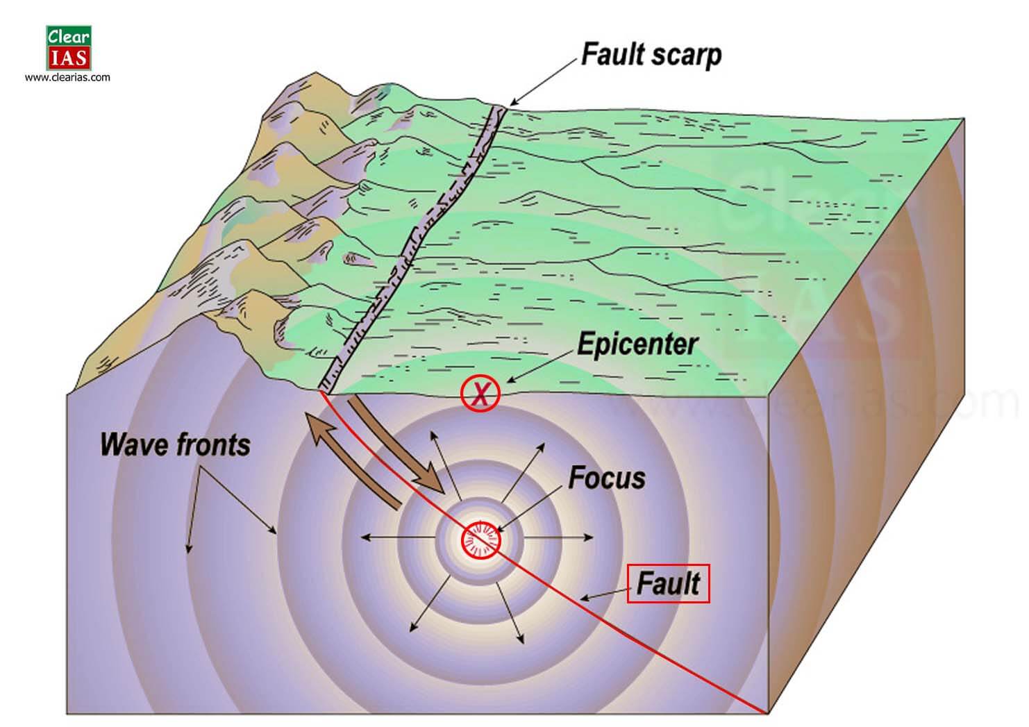
- The point within the earth’s crust where an earthquake originates is called the focus hypocenter or seismic focus.
- It generally lies within a depth of 6 km in the earth’s crust.
- The point vertically above the focus on the earth’s surface is called as the epicenter.
- The intensity of the earthquake will be highest in the epicenter and decrease as one moves away.
- All natural earthquakes take place in the lithosphere (i.e., the region that constitutes the earth’s crust and rigid upper part of the mantle).
Causes of Earthquakes
Earthquakes are primarily caused by the movement of tectonic plates beneath the Earth’s surface. These plates are large sections of the Earth’s crust that float on the semi-fluid layer of the mantle.
There are three main types of plate boundaries where earthquakes are common:
- Divergent Boundaries: Plates move away from each other, creating tension and often resulting in earthquakes.
- Convergent Boundaries: Plates move toward each other, leading to compression and causing earthquakes.
- Transform Boundaries: Plates slide past each other horizontally, generating shear stress and causing earthquakes.
Earthquake waves or Seismic waves
- The earthquake which originates in the lithosphere propagates different seismic waves or earthquake waves.
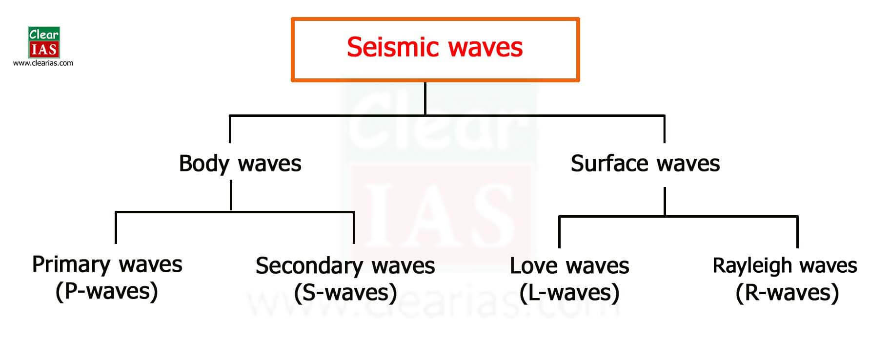
- Earthquake waves are basically of two types – body waves and surface waves.
Body waves
- They are generated due to the release of energy at the focus and move in all directions traveling through the body of the earth. Hence, the name – body waves.
- They travel only through the interior of the earth.
- Body waves are faster than surface waves and hence they are the first to be detected on a seismograph.
- There are two types of body waves primary waves and secondary waves.
Primary waves (p-waves)
- Primary waves are the fastest body waves (twice the speed of s-waves) and are the first to reach during an earthquake.
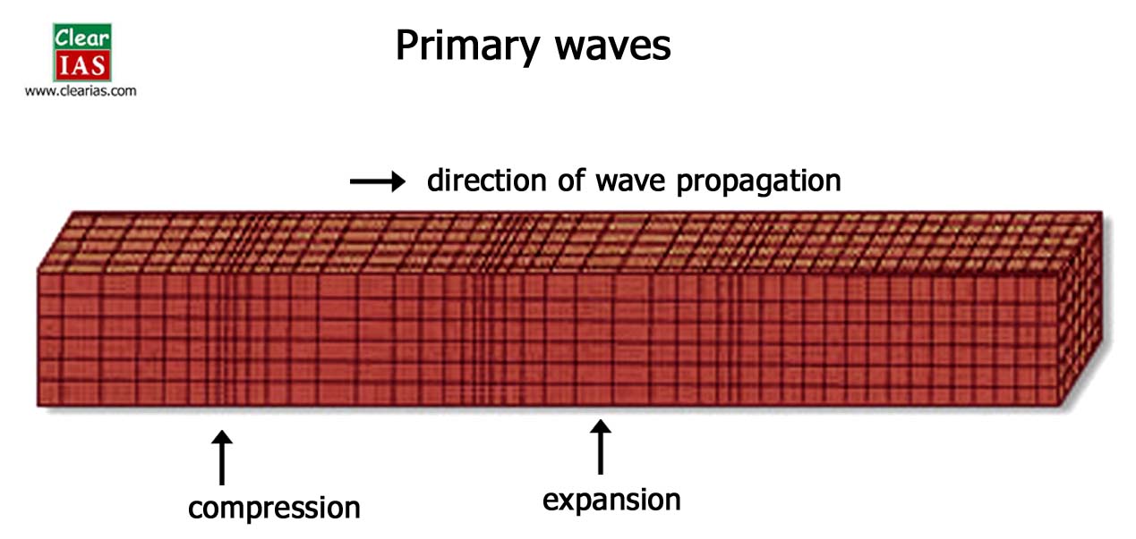
- They are similar to sound waves, i.e., they are longitudinal waves, in which particle movement is in the same direction of wave propagation.
- They travel through solid, liquid, and gaseous materials.
- They create density differences in the earth material leading to stretching and squeezing.
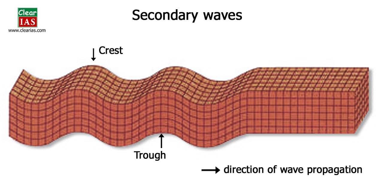
Secondary waves (s-waves)
- They arrive at the surface with some time lag after primary waves.
- They are slower than primary waves and can pass only through solid materials.
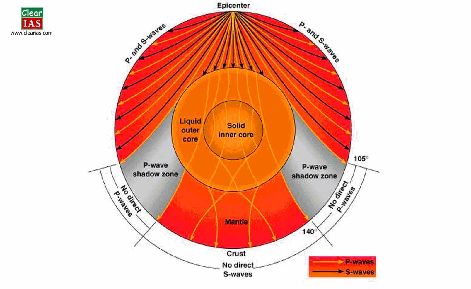
- This property of s-waves led seismologists to conclude that the earth’s outer core is in a liquid state. (the entire zone beyond 105o from the epicenter does not receive S-waves)
- They are transverse waves in which directions of particle movement and wave propagation are perpendicular to each other.
Surface Waves
- When the body waves interact with surface rocks, a new set of waves is generated called surface waves.
- These waves move along the earth’s surface.
- Surface waves are also transverse waves in which particle movement is perpendicular to the wave propagation.
- Hence, they create crests and troughs in the material through which they pass.
- Surface waves are considered to be the most damaging waves.
- Two common surface waves are Love waves and Rayleigh waves.
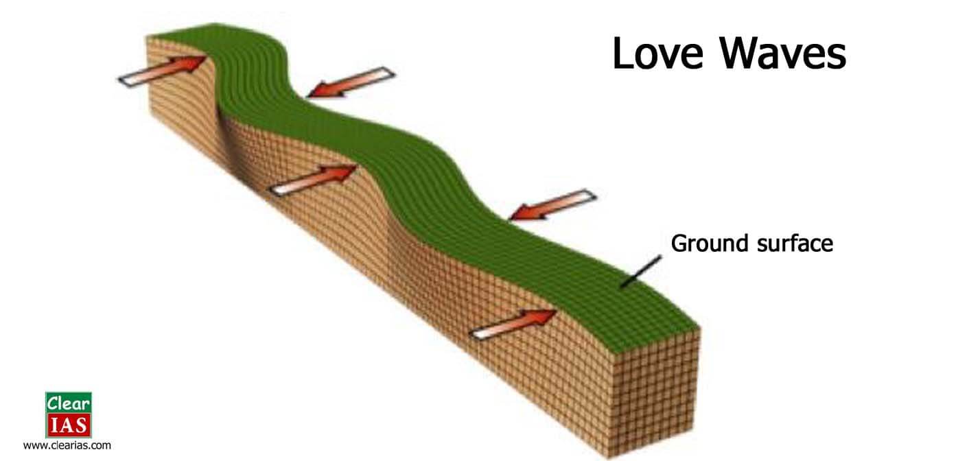
Love waves
- This kind of surface wave causes horizontal shifting of the earth during an earthquake.
- They are much slower than body waves but are faster than Rayleigh.
- They exist only in the presence of a semi-infinite medium overlain by an upper finite thickness.
- Confined to the surface of the crust, Love waves produce entirely horizontal motion.
Rayleigh waves
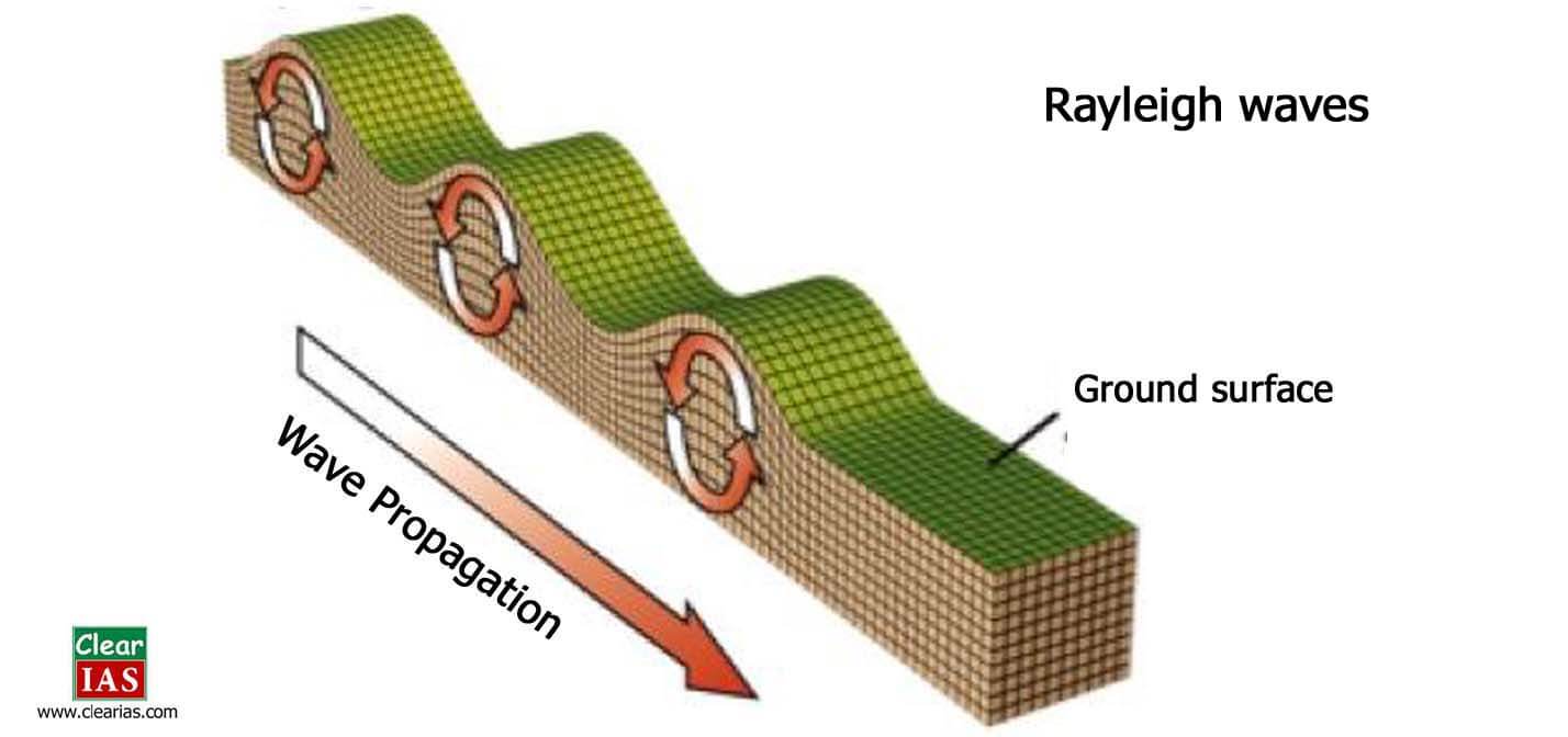
- These waves follow an elliptical motion.
- A Rayleigh wave rolls along the ground just like a wave rolls across a lake or an ocean.
- Because it rolls, it moves the ground up and down and side-to-side in the same direction that the wave is moving.
- Most of the shaking felt from an earthquake is due to the Rayleigh wave, which can be much larger than the other waves.
Shadow regions of waves
- We already discussed that p-waves pass through all mediums while S-waves pass only through solid mediums.
- With the help of these properties of primary waves, seismologists have a fair idea about the interior of the earth.
- Even though p-waves pass through all mediums, they cause reflection when they enter from one medium to another.
- The variations in the direction of waves are inferred with the help of their record on seismographs.
- The area where the seismograph records no waves is called as ‘shadow zone’ of that wave.
- Accordingly, it is observed that the area beyond 1050 does not receive S-waves, and the area between 1050 to 1400 does not receive P-waves.
Measuring earthquakes
- Seismometers are the instruments that are used to measure the motion of the ground, which includes those seismic waves generated by earthquakes, volcanic eruptions, and other seismic sources.
- A Seismograph is also another term used to mean seismometer though it is more applicable to older instruments.
- The recorded graphical output from a seismometer/seismograph is called as a seismogram. (Note: Do not confuse seismograph with seismogram. A seismograph is an instrument while a seismogram is the recorded output)
- There are two main scales used in the seismometers: (1) the Mercalli Scale and the Richter Scale.
Mercalli Scale
The scale represents the intensity of the earthquake by analyzing the after-effects like how many people felt it, how much destruction occurred etc. The range of intensity is from 1-12.
Also read: Avalanche: Types, Causes and Mitigation
Richter Scale
The scale represents the magnitude of the earthquake. The magnitude is expressed in absolute numbers from 1-10. Each whole number increase in the Richter scale represents a tenfold increase in the power of an earthquake.
Distribution of Earthquakes
There are two well-defined belts where earthquakes frequently occur – The Circum-Pacific Belt and The Mid-World Mountain Belt.
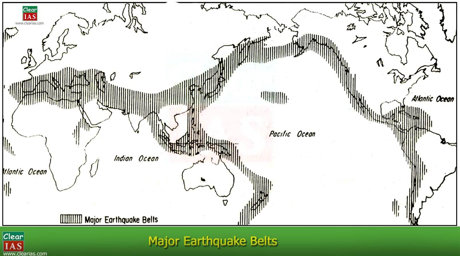
- About 68% of earthquakes in the world occur in the Circum-Pacific Belt.
- The mid-World Mountain belt extends from the Alps with extension into the Mediterranean, the Caucasus, and the Himalayan region and continues to Indonesia.
- 21% of earthquakes are occurring in this belt.
- The remaining 11% occur in the other parts of the world.
Next in the series: Exogenic Forces and their classification.
Article by: Jijo Sudarshan


Highly helpful
Splendid keep the good work up ,really helpful
Simplified and helpfull
This the best piece of work I have read so far! Precise yet detailed. Easy to understand and the phrasing is really good. Thank you so much!
superb sir, for me it was never so easy to understad.Thank You so much!!!
extremely helpful #simplified
Thank You for the Positive feedback.
Thanks…
Really grt work….
Words are not enough to compliment you ..thanku sir..very very helpful and easy to understand and the contents are in a proper manner..
Really very nice and easily understands ,help’s me a lot thank you
Thank you clear IAS……. Thanks a lot
good work
It’s wonderful everything thing arrange in to sysmetic manner thanks alot
very useful for freashers
Data kam hai
par Accha hai
Best platform for upsc preparation I have seen till date
@Vinay – Thank you for the feedback. All the best for UPSC exams!
Aslam u alaikum sir I need somes PDF notes of Geography
Very Good content ,perfect point wise data for purpose of short note
Thanks a lot .
very crisp content
why does L waves do not have a shadow?
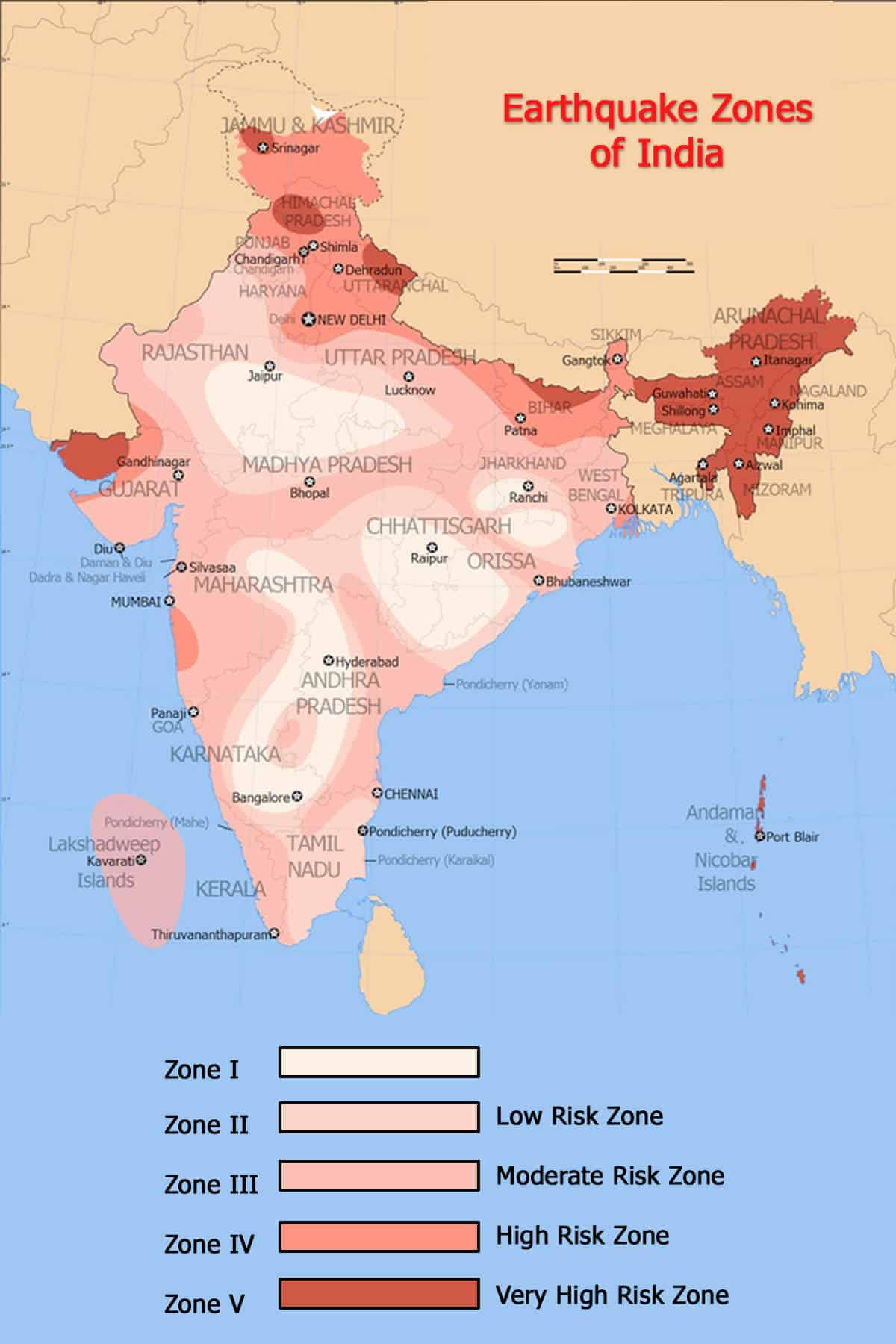
Why PoK and Aksai Chin regions are not included in the map of India??
Go and claim it by yourself…
The shadow zone of P-waves appears as a band
around the earth between 105 ° and 145 ° away
from the epicentre.
But in article defined as following
Accordingly, it is observed that the area beyond 105 does not receive S-waves and the area in between 105 to 140 does not receive P-waves.
Helpful of a better notes.
This article says
Even though p-waves pass through all mediums, they cause reflection when they enter from one medium to another
Corrected
Even though p-waves pass through all mediums, they cause refraction when they enter from one medium to another