What is Plate Tectonic Theory? What are the first and second relief features? What is the importance of the theory? To answer these questions, read further.
In 1957 McKenzie and Parker suggested the plate tectonic theory. The theory was propounded in 1967 by Morgan by taking some attributes from all previous theories of geomorphology.
Both conventional current theory and seafloor spreading theory paved the way for the theory of plate tectonics.
The theory provides substantial and scientific evidence about the present configuration of the first order and the process of origin of every second-order relief feature.
Plate Tectonic Theory

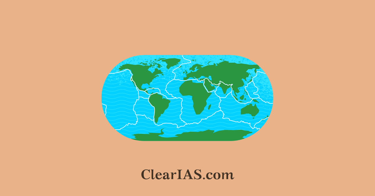
The plate tectonic theory is a fundamental concept in geology that explains the movement of the Earth’s lithospheric plates, which make up the Earth’s outermost shell.
This theory provides a comprehensive framework for understanding the dynamic processes that shape the Earth’s surface, including the formation of continents, ocean basins, mountains, earthquakes, and volcanic activity.
- The Earth’s lithosphere is divided into several large and smaller plates that float on the semi-fluid asthenosphere beneath them. These plates are made up of the Earth’s crust and the uppermost part of the mantle.
- Plate tectonics is driven by the movement of the Earth’s mantle, specifically convection currents. The heat from the Earth’s interior causes the mantle to convect, creating circulation patterns. This movement of material in the mantle drags the overlying lithospheric plates with it.
Plate Boundaries
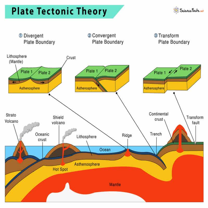
The boundaries between these lithospheric plates are where most of the Earth’s geological activity occurs. There are three main types of plate boundaries:
- Divergent Boundaries: Plates move away from each other. This can result in the formation of mid-ocean ridges and rift valleys.
- Convergent Boundaries: Plates move toward each other. When oceanic plates collide with continental plates, subduction zones, and mountain ranges can form. Oceanic-continental convergence can lead to volcanic arcs. Continental-continental convergence can create high mountain ranges.
- Transform Boundaries: Plates slide past each other horizontally. This can lead to strike-slip faults and earthquakes.
The theory of plate tectonics is based on 4 general geomorphological assumptions
- Firstly the slab or zone of the lithosphere is divided into several vertical columns geomorphological known as plates drifting kinematically over a semi-molten asthenosphere called a tectonic.
- Secondly, the surface area of a continental plate is also extended over the oceanic lithosphere. Thus, there is no complete segregation between the continental and the oceanic lithosphere. In this way, the theory again rejects the primary contention of Alfred Wegener that Continental sial and oceanic Sima are two different lithospheric entities.
- Thirdly, the movement or tectonics of the respective plates depends on the direction and the impulse action of the thermal Convection currents. consequently, the plates are converging and also divergent away from each other.
- Lastly, the process of convergence and divergence further creates a new crust over the Earth’s surface and also disintegrates the crust apart. The rate of formation and disintegration of the crust has acquired a profile of equilibrium by which the surface area of the earth remains constant.
The first orderly relief features
According to the plate tectonic theory, in the carboniferous period, the Pangea was segregated into two disrupted Continental blocks by the divergence of convection currents and the location of hotspots between the blocks.
The southern block of Gondwanaland further cross a hotspot and get segregated into the Northern and Southern block. In the present geological timescale, the southern block is known as Antarctica, and the northern block is the plates of South America, Africa, India, and Australia.
The physical location of the Indian block was initially between the plates of Africa and Antarctica and for the last 200 million years, the continental block of India has been drifting northeast over the asthenosphere.
Approximately 120 million years ago the physical location of the Indian block was near the equator and at the same time, the plate of India was segregated from the continental blocks of Africa.
Evidence in support of separation
The plate tectonic theory is supported by various lines of evidence, including:
- The fit of continents (e.g., the jigsaw puzzle fit of South America and Africa)
- The distribution of earthquakes and volcanoes along plate boundaries
- The age of oceanic crust (youngest at mid-ocean ridges and oldest at continental margins)
- The magnetic striping pattern of oceanic crust
The evidence in support of such separation is very well-identified along the eastern and western margin of the Africa Indian block respectively, characterized by the presence of the central fault line and volcanic deposition.
With time, the plate of Australia also gets segregated from the Indian block and substantial shreds of evidence of such tectonic movements are identified in the center of the Indian Ocean by the presence of the Central fault line and made Indian oceanic ridge.
The tectonic movement of respective plates and segregation of Continental blocks for each other further created an intervening space between the horizontally displacing block filled by oceanic water of Panthalassa to give rise to oceanic basins like the Pacific, Atlantic, and the Indian Ocean.
The origin of the second orderly relief features
Due to the plate tectonic theory, we got to know that the major geomorphological features such as fold and block mountains, mid-oceanic ridges, trenches, volcanism, earthquakes, etc. are a direct consequence of the interaction between the various lithospheric plates.
Three different types of tectonic borders:
- Where plates collide is a convergence.
- Divergent, in which the plates separate.
- When plates transform, they shift sideways concerning one another.
The interactions between plates are responsible for a wide range of geological phenomena, including the formation of mountain ranges (e.g., the Himalayas), ocean basins (e.g., the Atlantic Ocean), earthquakes along faults, volcanic eruptions, and the creation and destruction of oceanic crust.
The behavior of plates at their margins varies depending on the type of boundary. For example, at convergent boundaries, subduction zones can lead to the recycling of oceanic crust into the mantle, while at divergent boundaries, new crust is formed.
Convergent Boundaries
- When tectonic plates collide with one another, a convergent plate boundary is created. They are known as term “destructive boundaries” as well.
- These borders are frequently subduction zones, where a deep trench is formed as a heavier plate slides beneath a lighter plate.
- In addition to creating subduction zones, convergent plate boundaries can cause mountain ranges and island arcs to form.
- The collision can lead to the subduction of one plate beneath another, where one plate is pushed into the Earth’s mantle, creating deep-sea trenches, volcanic arcs, and earthquakes.
- When two continental plates collide, they can also create large mountain ranges.
Convergence can happen in three different ways:
- between a continental and oceanic plate (Andes Mountains)
- between two continental plates (The Himalayas)
- two oceanic plates (Mariana Trench)
Divergent Boundaries
- The breaking apart of tectonic plates creates a divergent boundary. The term “constructive boundaries” refers to them.
- At divergent plate boundaries, tectonic plates move away from each other.
- This movement creates tensional stress that results in the formation of a new crust. As the plates separate, magma from the mantle rises to fill the gap, leading to the formation of mid-ocean ridges.
- Divergent boundaries are often associated with volcanic activity and earthquakes, although the earthquakes tend to be relatively mild compared to those at other types of plate boundaries.
- Rift valleys and seafloor spreading are found at divergent boundaries.
- The Mid-Atlantic Ridge, which divides the American Plate from the Eurasian and African Plates, is the most well-known example of diverging borders.
- Examples: Mid-Atlantic Ridge, East African Rift, Mid-Indian Ridge
Transform Boundaries
- Tectonic plates glide past one another horizontally to form a transform boundary, however, some of these plates become stuck where they touch.
- Due to plate interaction, the crust is neither created nor destroyed, hence these boundaries are conservative. As a result, they don’t create amazing features like mountains or oceans.
- Stress builds in these points of contact, causing the rocks to break or slide. Faults are these slippage or breakage regions. The majority of Earth’s faults are located in the Ring of Fire along transform boundaries.
- Transform boundaries are often associated with significant seismic activity and can produce powerful earthquakes.
- Examples: San Andreas Fault (North American Plate and Pacific Plate); North Anatolian Fault (Eurasian Plate and Anatolian Plate); Alpine Fault (Pacific Plate and Indo-Australian Plate).
In addition to these primary types of plate boundaries, there are complex regions where the interactions between plates are not neatly categorized into one type. These regions can exhibit a combination of features associated with divergent, convergent, and transform boundaries.
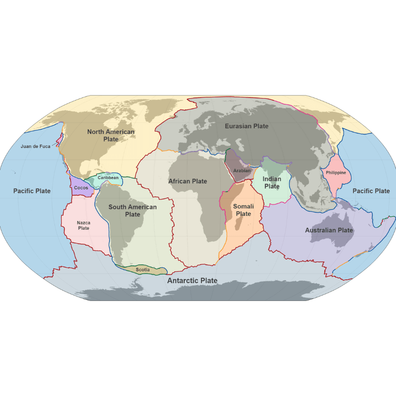
Major Tectonic Plates

- Antarctica and the surrounding oceanic plate
- North American plate
- South American plate
- Pacific plate
- India-Australia-New Zealand plate
- Africa with the eastern Atlantic floor plate
- Eurasia and the adjacent oceanic plate
Minor Tectonic Plates
- Arabian plate: Mostly the Saudi Arabian landmass
- Bismark Plate (North Bismarck Plate & South Bismarck Plate)
- Caribbean plate
- Carolina plate [straddles the Equator in the eastern hemisphere located north of New Guinea]
- Cocos Plate
- Juan de Fuca Plate (between Pacific and North American plates)
- Nazca plate
- Philippine plate: Between the Asiatic and Pacific plate
- Persian Plate
- The Anatolian Plate [or the Turkish Plate is a continental tectonic plate comprising most of the Anatolia (Asia Minor) peninsula and the country of Turkey.
- China plate.
- Fiji Plate ( located b/w the Pacific Plate and the Indo-Australia Plate )
Significance of plate tectonic theory
Plate tectonics explains the distribution of continents and oceans, the formation of mountain ranges, the opening and closing of ocean basins, and the generation of geological hazards such as earthquakes and volcanic eruptions.
- Plate tectonics is responsible for creating almost all significant landforms.
- Magmatic eruptions cause the core to spew out new materials.
- Minerals with high economic value, such as copper and uranium, are located close to plate borders.
- The future shape of landmasses can be anticipated using the current understanding of crustal plate movement.
- For instance, North and South America will split if current patterns continue. The east coast of Africa will split off into a new region. Australia will approach Asia.
In news
Study on Ninetyeast Ridge
The recent Nature Communications study offers groundbreaking insights into the origin and formation of the Ninetyeast Ridge, the Earth’s longest straight underwater mountain chain. The findings challenge earlier assumptions about stationary hotspots and enhance our understanding of Earth’s tectonic processes.
1. Formation by a Moving Hotspot
- The study establishes that the Ninetyeast Ridge was formed by the Kerguelen hotspot, a volcanic hotspot located at the Kerguelen Plateau in the Southern Indian Ocean.
- Contrary to the earlier belief that a stationary hotspot created the ridge, the Kerguelen hotspot moved several hundred kilometers within the Earth’s mantle during the ridge’s formation.
- This is the first documented instance of a moving hotspot in the Indian Ocean, providing direct evidence of hotspot mobility—a concept that has been theoretically proposed but challenging to confirm.
2. Age Estimates
- Using high-precision dating of mineral samples from the ridge, researchers determined its formation occurred between 83 million and 43 million years ago.
- This refined timeline contributes to more accurate models of tectonic and mantle dynamics.
3. Impact on Tectonic Models
- The findings revise existing models of Earth’s tectonic history by integrating the role of dynamic hotspot movement in shaping underwater geological features.
- The study underscores the significance of understanding mantle dynamics, as hotspot movement can influence plate tectonics, volcanic activity, and even the distribution of seafloor features.
- Insights into hotspot dynamics may improve predictions of natural disasters like earthquakes and volcanic eruptions by enhancing our understanding of mantle-plume interactions.
How Do Hotspots Impact Tectonic Plates and Natural Disasters?
Hotspots, regions where mantle plumes rise toward the Earth’s surface, play a significant role in shaping tectonic plate behavior and influencing natural disasters. Their impact is evident in volcanic chains, plate movements, rifting, earthquakes, and tsunamis.
Hotspot Influence on Tectonic Plates:
- Volcanic Chains and Plate Movement
- Formation of Island Chains: As a tectonic plate moves over a stationary hotspot, a sequence of volcanoes or islands is created. The youngest volcano forms directly above the hotspot, while older ones are carried away by plate movement, forming a volcanic chain.
- Example: The Hawaiian Islands, where the Island of Hawaii is the youngest and most active.
- Evidence of Plate Motion: The age progression of these volcanic islands, from youngest to oldest, provides direct evidence of plate movement.
- Estimating Plate Speed: By measuring the distance between islands and their formation ages, scientists can calculate the speed of tectonic plates.
- Formation of Island Chains: As a tectonic plate moves over a stationary hotspot, a sequence of volcanoes or islands is created. The youngest volcano forms directly above the hotspot, while older ones are carried away by plate movement, forming a volcanic chain.
- Geothermal Features and Plate Interactions
- Hotspots generate geothermal features such as geysers and hydrothermal vents, offering insights into the heat flow and tectonic interactions beneath the crust.
- Driving Plate Tectonics
- Heat and Motion: Mantle plumes supply heat and energy, driving the large-scale motion of tectonic plates.
- Rifting and Continental Breakup
- Hotspots can contribute to continental rifting, where tectonic plates diverge and continents split apart.
- Mechanism: A mantle plume beneath a continent weakens the lithosphere, causing it to stretch and break apart.
- Example: The East African Rift, where Africa is slowly splitting into separate landmasses.
- Hotspots can contribute to continental rifting, where tectonic plates diverge and continents split apart.
Hotspot Influence on Natural Disasters:
- Earthquakes
- Mechanism: Mantle plumes and their interactions with tectonic plates can create stresses that lead to earthquakes.
- Prediction: Understanding these dynamics helps scientists identify seismic risk zones and design early warning systems.
- Tsunamis
- Triggers: Submarine earthquakes and volcanic eruptions caused by mantle plume activity can generate tsunamis.
- Preparedness: By studying hotspot activity and mantle dynamics, scientists can improve tsunami prediction models and issue timely warnings to mitigate coastal impacts.
Conclusion
The great unifying theory of geosciences that describes how continents move is called plate tectonics. Most significant landforms on Earth’s surface, such as mountains, mid-ocean ridges, and the production of the new lithosphere are caused by volcanism and earthquakes.
The plate tectonic theory has revolutionized our understanding of the Earth’s geology and has become a unifying principle in the field of earth sciences.
It provides a framework for explaining the dynamic processes that have shaped the Earth’s surface over millions of years and continue to do so today.
Article written by Chetna Yadav.


Leave a Reply