The Pacific Decadal Oscillation (PDO) is a long-term climate pattern characterized by variations in sea surface temperatures (SSTs) and atmospheric conditions in the North Pacific Ocean. Read here to learn more about PDO.
A recent study reported that a combination of global warming and a cyclical event called the Pacific Decadal Oscillation which repeats every 20-30 years, could make cyclones that originate near the Equator more frequent in the coming years
The number of equatorial-origin cyclones was 43% fewer in 1981-2010 compared with 1951-1980, and this was because the PDO was in a ‘warmer’ or positive phase.
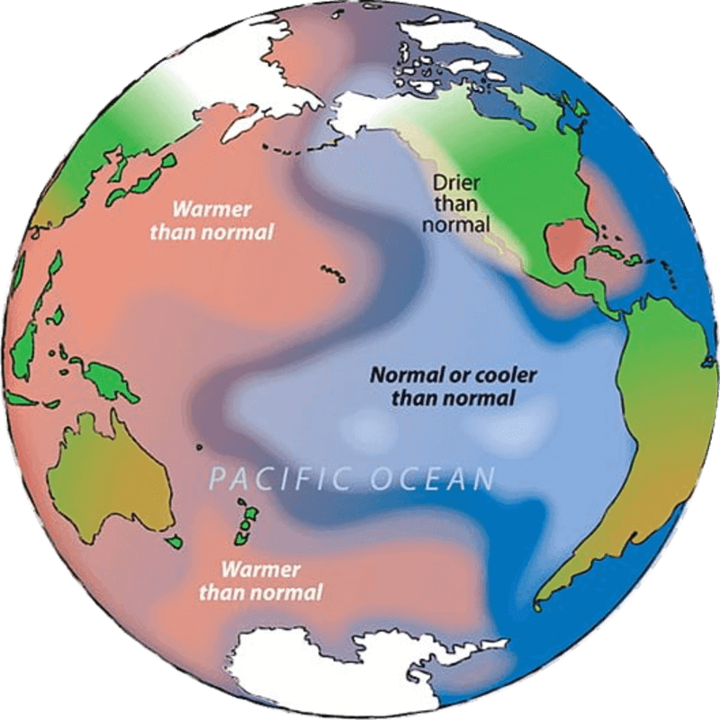
Unlike ENSO, the PDO isn’t an annual occurrence and, on average, corresponds to a warmer than average Western Pacific Ocean and relatively cooler Eastern Pacific, though this plays out over much longer time scales.
Pacific Decadal Oscillation (PDO)
The Pacific Decadal Oscillation (PDO) is a long-term climate pattern that affects the temperature of the Pacific Ocean and the weather patterns around it.
The PDO is a naturally occurring phenomenon that shifts between warm and cool phases, with each phase lasting around 20-30 years.
- The Pacific Decadal Oscillation can strongly impact global weather and is important in long-range weather forecasting.
- It typically spans several decades, and its phases have significant impacts on climate and weather patterns, particularly in the North Pacific region.
The PDO is analogous to the El Niño-Southern Oscillation (ENSO) but operates on a longer timescale and has different effects.
Key characteristics of the Pacific Decadal Oscillation include:
Positive and Negative Phases:
- The PDO has two primary phases: positive (warm) and negative (cool). During the positive phase, the eastern North Pacific tends to be warmer than average, while during the negative phase, it tends to be cooler than average.
- The positive phase is characterized by cool SSTs north of Hawaii and warmer-than-normal sea surface temperatures along the western coast of North America.
- The negative phase is a mirror image with warm ocean temperatures in the Central North Pacific and cooler than normal waters along the western coast of North America.
Spatial Patterns:
- The positive phase is associated with a horseshoe-shaped pattern of above-average sea surface temperatures, with warm waters extending along the western coast of North America and into the central North Pacific.
- In the negative phase, the pattern is reversed, with cooler waters along the western coast of North America.
Duration:
- The PDO is a long-term climate pattern that typically lasts for 20 to 30 years in one phase before transitioning to the opposite phase. However, the timing and duration of these phases can vary considerably.
Natural Climate Variability:
- The PDO is considered a part of natural climate variability and is driven by a combination of oceanic and atmospheric processes.
- It is not directly related to human-induced climate change, although it can interact with and modulate the effects of climate change in certain regions.
Impact of Pacific Decadal Oscillation

The PDO can influence weather patterns, ocean conditions, and ecosystems over a wide area, including North America and the North Pacific region.
Positive Phase Impacts
- During the positive phase, it is often associated with milder winters in the western United States, increased rainfall in the Pacific Northwest, and changes in marine ecosystems.
- The Northern Rockies and the Midwest are likely to be drier than normal, while Texas, the Gulf states, and the East are likely to be wetter than normal.
- During the positive phase of the PDO in the northern hemisphere wintertime, much of Asia is usually cooler than normal, with above-normal temperatures more likely over India.
- At the same time, China and Japan are likely to be drier than normal, while India often has a winter that is wetter than normal.
Negative Phase Impacts
- During the negative phase, it can lead to colder winters in the western U.S., drier conditions in the Pacific Northwest, and different marine ecosystem dynamics.
- Many parts of the US will see drier than normal weather, but there are some notable exceptions.
- During a negative PDO, winter rainfall is usually above normal for the Ohio and Tennessee Valleys as well as the Northern Rockies and Plains.
- During the negative phase of the PDO in the northern hemisphere wintertime, much of India and China is usually cooler than normal, But Japan has warmer than normal weather, especially in the North.
- At the same time, Japan and Northwest China are usually wetter than normal, while Southwest China and much of India are usually wetter than normal
PDO vs ENSO
It’s important to note that the PDO is distinct from ENSO, which operates on a shorter timescale (typically 2 to 7 years) and involves interactions between the ocean and atmosphere in the tropical Pacific.
However, there can be interactions between the PDO and ENSO, where the phase of one pattern can influence or reinforce the phase of the other.
Parameter |
PDO |
ENSO |
Timescale |
The PDO is a long-term climate pattern that varies on decadal to multi-decadal timescales, typically ranging from 20 to 30 years for each phase. |
ENSO is a shorter-term climate phenomenon, with irregular cycles that typically last 2 to 7 years. It has two primary phases: El Niño (warm) and La Niña (cool), with a neutral phase in between. |
Nature |
The PDO is characterized by a shift in sea surface temperature (SST) patterns in the North Pacific Ocean. It involves the alternation between warm (positive) and cool (negative) phases. |
ENSO involves changes in sea surface temperatures and atmospheric pressure patterns in the tropical Pacific Ocean, primarily in the eastern and central equatorial Pacific. |
Geographic scope |
The PDO affects the entire North Pacific Ocean, from the west coast of North America to Japan and beyond. |
ENSO’s primary impacts are felt in the tropical Pacific region, but it has far-reaching global consequences. |
Oceanic and atmospheric effects |
The PDO primarily influences sea surface temperatures and oceanic patterns in the North Pacific. It can have secondary effects on atmospheric circulation, precipitation patterns, and climate conditions in the surrounding regions. |
ENSO can lead to significant shifts in atmospheric circulation, altering weather patterns, precipitation, and temperature anomalies across the Pacific basin and beyond. |
Impact |
The PDO can influence weather patterns and climate conditions over extended periods, affecting fisheries, marine ecosystems, and even temperature and precipitation patterns in North America. |
ENSO can have profound and immediate impacts on global weather and climate. El Niño is associated with warm oceanic conditions and can lead to droughts, flooding, and extreme weather events, while La Niña tends to have the opposite effects. |
Conclusion
PDO and ENSO are distinct climate phenomena, each with its timescale, geographic scope, and influence on oceanic and atmospheric conditions. Understanding these patterns is essential for climate forecasting and assessing their impacts on weather, agriculture, and ecosystems.
Scientists monitor the PDO to understand its phase and anticipate its impacts on regional climate and ecosystems. Understanding the PDO can be valuable for various sectors, including agriculture, fisheries, and water resource management, as it provides insights into long-term climate patterns in the North Pacific region.
-Article by Swathi Satish


Leave a Reply